
Location, Location, Location
Location is key when it comes to providing a service - it impacts the expected number of customers, profit and performance. There are many things to consider when selecting a service location.
Where are the existing services?
Who are the expected clientele?
Where are the clientele now and where might they be in the future?
Data Analysis Australia has the expertise and experience in service placement required to optimise performance in both the short and long term.
Service placement is applicable across many different industries, from equitable access to social services through to planning the next fast food take-away. With each industry we can deliver a tailored approach providing real strategic insights for our clients.
This Analytical Idea gives an example in a field that affects us all - emergency medical services. We look at existing services in the Perth metropolitan area to identify optimal, or not so optimal, locations from a service users’ perspective - measured by expected time until receiving care.
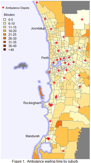
Waiting for an Ambulance
Ambulance depots are displayed in Figure 1 . We also display calculated travel times from the closest station to each suburb. The calculations used the street network and reasonable assumptions about speed – in emergencies ambulances may be a bit faster, but this is still a good guide. Provided an ambulance is available at the nearest station, most suburbs around the central metropolitan area of Perth should expect less than 10 minutes waiting time to receive care.
There are suburbs along the coast north of the Swan River (including Scarborough, Karrinyup, North Beach and Sorrento) and suburbs south of the river (including Canning Vale, Thornlie, Bibra Lake and Coolbellup) that are close to the central Perth area but have relatively longer waiting times of up to 15 minutes. In general, however, the ambulance stations theoretically provide reasonable coverage of the Perth metro area.
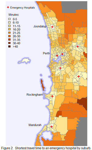
Getting to the Hospital
The time spent waiting for an ambulance is only part of the picture – to think globally we need to also consider the subsequent travel time to an emergency hospital. As there are fewer hospitals than ambulance depots, the routes are typically longer.
While suburbs in the north-east and south-east part of the central metropolitan area (suburbs surrounding Mirrabooka and Beckenham) had a short delay in expecting an ambulance, they can expect a longer journey to hospital. We’ve only used general emergency hospitals for this example, excluding the children’s and maternity hospitals, and assume that the hospital is selected based only on the shortest route. Similarly to the ambulance waiting time, the travel times are displayed in a map (Figure 2).
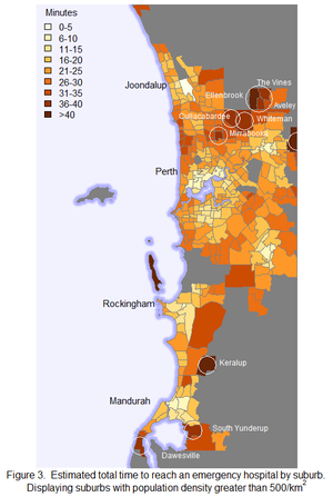
The Combined Picture
It is important to combine both legs of the ambulance’s journey (to the patient and then the hospital) to have a perspective of the bigger picture (Figure 3). To focus on the most relevant areas, we’ve limited the map to more densely populated suburbs (at least 500 people per square kilometre).
In this scenario, we can expect to take less than 25 minutes to reach an emergency hospital via an ambulance from most suburbs in Perth. Areas in the north-east corridor such as Ellenbrook, The Vines, Aveley and Mirrabooka are looking at more than 30 minutes due to the lack of efficient routes to hospital. We also see longer times around the north coast (Scarborough, Karrinyup and Sorrento), which highlights limited access routes for coastal areas, as services can only be located to their east (i.e. on land).
Next Steps
This geographical analysis is only part of the whole picture that needs to be considered. Even the geographical component can be considered in more detail. How do we take these insights to the next level? Of course, there are many different layers of complexity we could consider.
- How can we make this more accurate and realistic? Through consultation with key stakeholders, further research, and looking at geographical areas that are smaller than suburbs.
- Where do users of emergency services live? Consider weighting by number of people in the suburbs, or both number of people and demographics of those likely to require services.
- How might demand change in the future? Use population projections to see where those demographics might be in the future – think of long term stability.
- Where do people have their emergencies? Look beyond residence and consider other factors such as traffic accident hot-spots, sports stadiums, entertainment areas, etc.
- Are we considering building a new hospital(s)? Based on our simple example, the North-East corridor seems the most likely candidate. The number of hospitals matters. If it was just one you’d locate it fairly central to this corridor. If it was two, you might have one near Mirrabooka and another in Ellenbrook – depending on expected population growth in that area.
- What about how many of the existing fleet of ambulances should be based at each station? This would involve analysing the historical demand, predicting future demand and solving an optimisation problem where the objective could be to minimise average (or average maximum) waiting times. Given the complexity, a simulation approach could be required.
- Are we considering ambulance “roaming” plans? In this case we would focus on areas that are not efficiently accessible from the existing station locations.
- Do we have a new, expensive piece of hospital equipment to assign to an existing hospital? We’d look at the type and frequency of emergencies requiring this equipment for diagnosis/treatment and filter our analysis accordingly.
- How can we optimise services? Are changes to dispatching/hospital selection guidelines required to make emergency service access more equitable? Is it fair that people who live in more sparsely populated areas should wait longer for care? Perhaps local volunteer services can be planned here.
The problem has many layers and Data Analysis Australia have the broad expertise, experience and consulting skills to define and solve the problem at hand.
Data Sources:
Ambulance depot and hospital locations were sourced via desktop research and are for example purposes only – they may not accurately represent actual locations.
Population data used is based on the Estimated Residential Population as published by the Australia Bureau of Statistics (ABS). Official suburb boundary data for mapping is also sourced from the ABS.
September 2016